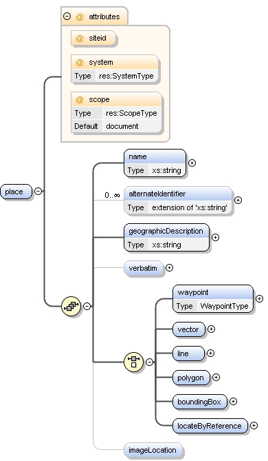
<xs:element name="place">
<xs:annotation>
<xs:documentation>anywhere samples are collected. could be a waypoint, plot, transect, area or bounding-box</xs:documentation>
</xs:annotation>
<xs:complexType>
<xs:sequence>
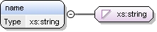
<xs:element name="name" type="xs:string"/>
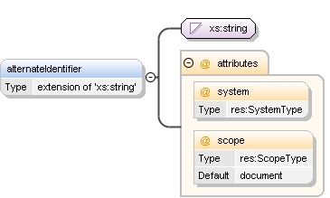
<xs:element name="alternateIdentifier" minOccurs="0" maxOccurs="unbounded">
<xs:annotation>
<xs:appinfo>
<doc:tooltip>Other identifiers for this location</doc:tooltip>
<doc:summary>Many of SBC's sampling sites are purposely co-located with those of other projects. If known, these should be listed here.</doc:summary>
<doc:description>
</doc:description>
<doc:example>SCCOOS: sbharbor, Plumes and Blooms: station4, USGS: 11199000</doc:example>
</xs:appinfo>
</xs:annotation>
<xs:complexType>
<xs:simpleContent>
<xs:extension base="xs:string">
<xs:attribute name="system" type="res:SystemType" use="optional"/>
<xs:attribute name="scope" type="res:ScopeType" use="optional" default="document"/>
</xs:extension>
</xs:simpleContent>
</xs:complexType>
</xs:element>
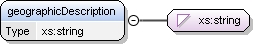
<xs:element name="geographicDescription" type="xs:string">
<xs:annotation>
<xs:appinfo>
<doc:tooltip>Description of geographic extent</doc:tooltip>
<doc:summary>Short description of the place. Include associated geographic names, landmarks, artificial markers, and any ancillary info which cannot be coded. Use this field to further restrict the location, e.g, two transects share the same waypoint-starting gPoint, but are actually separated by few meters</doc:summary>
<doc:description>
</doc:description>
<doc:example>Examples include, "Manistee River watershed", "transect beginning at eyebolt at far west end of Naples reef and extending due east", or "Arroyo Burro Creek between State Street bridge and the beach", "cruise station also sampled by Plumes and blooms project and by CCE"</doc:example>
</xs:appinfo>
</xs:annotation>
</xs:element>
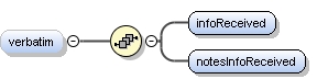
<xs:element name="verbatim" minOccurs="0">
<xs:annotation>
<xs:appinfo>
<doc:tooltip>Information as received</doc:tooltip>
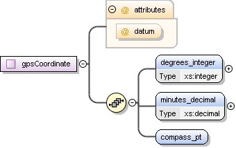
<doc:summary>locations, especially lats and longs are usually kept in degree + minute with compass direction attached, and are converted to decimals for this application. Store the original strings here.</doc:summary>
</xs:appinfo>
</xs:annotation>
<xs:complexType>
<xs:sequence>
<xs:element name="infoReceived">
<xs:annotation>
<xs:appinfo>
<doc:example>34deg 15.8 min N x 119deg 32.45 W</doc:example>
</xs:appinfo>
</xs:annotation>
</xs:element>
<xs:element name="notesInfoReceived">
<xs:annotation>
<xs:appinfo>
<doc:example>per clint nelson's excel sheet, 2007-01-01</doc:example>
</xs:appinfo>
</xs:annotation>
</xs:element>
</xs:sequence>
</xs:complexType>
</xs:element>
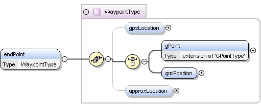
<xs:choice>
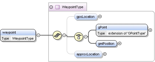
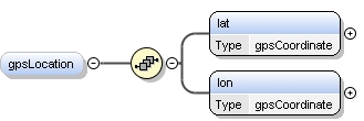
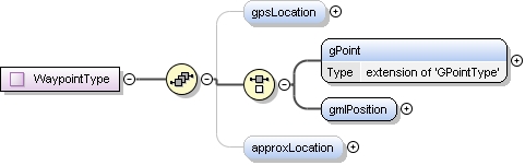
<xs:element name="waypoint" type="WaypointType"/>
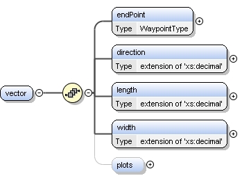
<xs:element name="vector">
<xs:annotation>
<xs:appinfo>
<doc:tooltip>Used for a sampling site designated by a starting lat-lon pair, a direction, length and width</doc:tooltip>
<doc:summary>census transects are usually defined by an endpoint, with a compass direction, length and width. The endpoint is a WaypointType, the direction, length and width are decimals. units are stored in the element's attribute</doc:summary>
</xs:appinfo>
<xs:documentation>a straight line defined by an endpoint, direction, length and width</xs:documentation>
</xs:annotation>
<xs:complexType>
<xs:sequence>
<xs:element name="endPoint" type="WaypointType">
<xs:annotation>
<xs:documentation>endpoint is a WaypointType</xs:documentation>
</xs:annotation>
</xs:element>
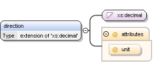
<xs:element name="direction">
<xs:complexType>
<xs:simpleContent>
<xs:extension base="xs:decimal">
<xs:attribute name="unit" use="optional"/>
</xs:extension>
</xs:simpleContent>
</xs:complexType>
</xs:element>
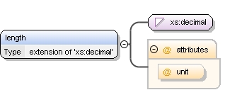
<xs:element name="length">
<xs:complexType>
<xs:simpleContent>
<xs:extension base="xs:decimal">
<xs:attribute name="unit" use="optional"/>
</xs:extension>
</xs:simpleContent>
</xs:complexType>
</xs:element>
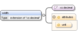
<xs:element name="width">
<xs:complexType>
<xs:simpleContent>
<xs:extension base="xs:decimal">
<xs:attribute name="unit" use="optional"/>
</xs:extension>
</xs:simpleContent>
</xs:complexType>
</xs:element>
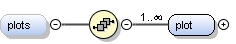
<xs:element name="plots" minOccurs="0">
<xs:annotation>
<xs:appinfo>
<doc:tooltip>Used for defining plots along a vector-type transect</doc:tooltip>
<doc:summary>not entirely sure how this information will be used. usually upc data is collected in 1-m quadrats along the same transect as large-animal censuses, alternating sides at approx 5m intervals, and numbered a,b,c or 1,2,3.</doc:summary>
</xs:appinfo>
<xs:documentation>maybe remove this, and define plots indivually using locateByReference instead.</xs:documentation>
</xs:annotation>
<xs:complexType>
<xs:sequence>
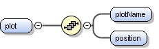
<xs:element name="plot" maxOccurs="unbounded">
<xs:complexType>
<xs:sequence>
<xs:element name="plotName"/>
<xs:element name="position"/>
</xs:sequence>
</xs:complexType>
</xs:element>
</xs:sequence>
</xs:complexType>
</xs:element>
</xs:sequence>
</xs:complexType>
</xs:element>
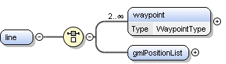
<xs:element name="line">
<xs:annotation>
<xs:appinfo>
<doc:tooltip>Describe a line or sampling transect by one or more lat-lon pairs</doc:tooltip>
<doc:summary>This tree could be used for any sampling line composed of at least 2 endpoints (and may include jogs). examples are ship transects, along shore transects. Tree can aslo be used for creeks or tributaries. Use either a sequence of GPointTypes, or a gml lineString (called a PositionList here)</doc:summary>
</xs:appinfo>
<xs:documentation>a string of at least 2 waypoints, or an unclosed curve</xs:documentation>
</xs:annotation>
<xs:complexType>
<xs:choice>
<xs:element name="waypoint" type="WaypointType" minOccurs="2" maxOccurs="unbounded"/>
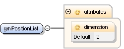
<xs:element name="gmlPositionList">
<xs:annotation>
<xs:appinfo>
<doc:tooltip>an alternative to separately coded lats and longs. gml string could go here</doc:tooltip>
<doc:summary>This field should be composed of at least 2 "lon lat" pairs (ie, x y, x y, x y) to denone. same caveats apply as for gmlPosition</doc:summary>
<doc:example>-120.8678 34.2222, -120.9000, 34.333</doc:example>
</xs:appinfo>
</xs:annotation>
<xs:complexType>
<xs:attribute name="dimension" default="2"/>
</xs:complexType>
</xs:element>
</xs:choice>
</xs:complexType>
</xs:element>
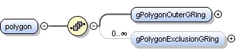
<xs:element name="polygon">
<xs:annotation>
<xs:appinfo>
<doc:tooltip>Polygon data set</doc:tooltip>
<doc:summary>This construct creates a spatial ring with a hollow center.</doc:summary>
<doc:description>This construct creates a spatial ring with a hollow center. This doughnut shape is specified by the outer ring (datasetGPolygonOuterRing) and the inner exclusion zone (datasetGPolygonExclusionGRing) which can be thought of as the hole in the center of a doughnut. This is useful for defining areas such as the shores of a pond where you only want to specify the shore excluding the pond itself.</doc:description>
<doc:example>Please see the individual sub-fields for specificexamples.</doc:example>
</xs:appinfo>
<xs:documentation>a closed shape with/without an excluded area</xs:documentation>
</xs:annotation>
<xs:complexType>
<xs:sequence>
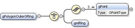
<xs:element name="gPolygonOuterGRing">
<xs:annotation>
<xs:appinfo>
<doc:tooltip>Outer polygon</doc:tooltip>
<doc:summary>The outer containment loop of a GPolygon.</doc:summary>
<doc:description>The outer containment loop of a datasetGPolygon. This is the outer part of the doughnut shape that encompasses the broadest area of coverage</doc:description>
</xs:appinfo>
</xs:annotation>
<xs:complexType>
<xs:choice>
<xs:sequence>
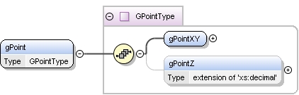
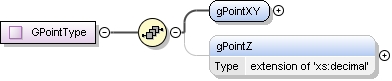
<xs:element name="gPoint" type="GPointType" minOccurs="3" maxOccurs="unbounded"/>
</xs:sequence>
<xs:element name="gmlRing"/>
</xs:choice>
</xs:complexType>
</xs:element>
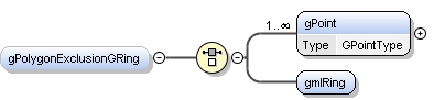
<xs:element name="gPolygonExclusionGRing" minOccurs="0" maxOccurs="unbounded">
<xs:annotation>
<xs:appinfo>
<doc:tooltip>Exclusion polygon</doc:tooltip>
<doc:summary>Data Set G-Polygon Exclusion G-Ring, the closed nonintersecting boundary of a void area (or hole in an interior area).</doc:summary>
<doc:description>Data Set G-Polygon Exclusion G-Ring, the closed nonintersecting boundary of a void area (or hole in an interior area). This is the center of the doughnut shape created by the datasetGPolygon. How do you inforce non-intersecting??</doc:description>
</xs:appinfo>
<xs:documentation>the void area, or center of the doughnut.</xs:documentation>
</xs:annotation>
<xs:complexType>
<xs:choice>
<xs:element name="gPoint" type="GPointType" maxOccurs="unbounded"/>
<xs:element name="gmlRing"/>
</xs:choice>
</xs:complexType>
</xs:element>
</xs:sequence>
</xs:complexType>
</xs:element>
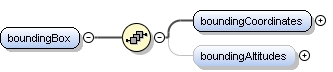
<xs:element name="boundingBox">
<xs:annotation>
<xs:documentation>copied from EML geographicCoverage, but altitude moved and datums added</xs:documentation>
</xs:annotation>
<xs:complexType>
<xs:sequence>
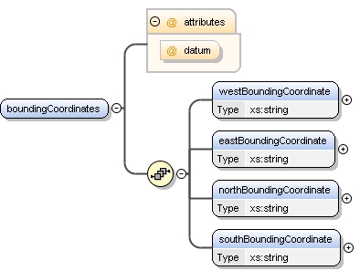
<xs:element name="boundingCoordinates">
<xs:complexType>
<xs:sequence>
<xs:element name="westBoundingCoordinate" type="xs:string"/>
<xs:element name="eastBoundingCoordinate" type="xs:string"/>
<xs:element name="northBoundingCoordinate" type="xs:string"/>
<xs:element name="southBoundingCoordinate" type="xs:string"/>
</xs:sequence>
<xs:attribute name="datum" use="optional"/>
</xs:complexType>
</xs:element>
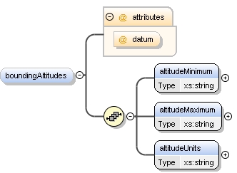
<xs:element name="boundingAltitudes" minOccurs="0">
<xs:complexType>
<xs:sequence>
<xs:element name="altitudeMinimum" type="xs:string"/>
<xs:element name="altitudeMaximum" type="xs:string"/>
<xs:element name="altitudeUnits" type="xs:string"/>
</xs:sequence>
<xs:attribute name="datum" use="optional"/>
</xs:complexType>
</xs:element>
</xs:sequence>
</xs:complexType>
</xs:element>
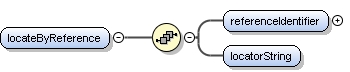
<xs:element name="locateByReference">
<xs:annotation>
<xs:appinfo>
<doc:tooltip>an alternative to separately coded lats and longs. Use this element for a point that is located by reference to another place</doc:tooltip>
<doc:summary>locations can be specified as "8meters along transect A", or "from aqm, 10meters at 340deg". transect A (or aqm) are places with existing descriptions</doc:summary>
<doc:example>10 ft SW of the big rock at the foot of goleta pier</doc:example>
<doc:example>8meters along transect LTRAQ1</doc:example>
</xs:appinfo>
<xs:documentation>describe this place using its relationship to another place. no attempt at referential integrity.</xs:documentation>
</xs:annotation>
<xs:complexType>
<xs:sequence>
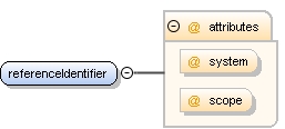
<xs:element name="referenceIdentifier">
<xs:annotation>
<xs:appinfo>
<doc:tooltip>The id of the place that will be referenced</doc:tooltip>
<doc:summary>the parent place of this place. for example, the id for the transect that this plot is located along</doc:summary>
<doc:example>LTRAQ1</doc:example>
</xs:appinfo>
<xs:documentation>The id of the place that will be referenced</xs:documentation>
</xs:annotation>
<xs:complexType>
<xs:attribute name="system"/>
<xs:attribute name="scope"/>
</xs:complexType>
</xs:element>
<xs:element name="locatorString">
<xs:annotation>
<xs:documentation>How to find this place from the reference place</xs:documentation>
<xs:appinfo>
<doc:tooltip>How to find this place from the reference place</doc:tooltip>
<doc:summary>This element typed xs:string to accomodate narrative descriptions</doc:summary>
<doc:example>10m at 340deg</doc:example>
<doc:example>8m</doc:example>
</xs:appinfo>
</xs:annotation>
</xs:element>
</xs:sequence>
</xs:complexType>
</xs:element>
</xs:choice>
<xs:element name="imageLocation" minOccurs="0">
<xs:annotation>
<xs:documentation>path on the file server or a url</xs:documentation>
<xs:appinfo>
<doc:tooltip>a path to an image file to accompany this place, either on the fileserver or a url</doc:tooltip>
<doc:summary>Some site description documents contain a small image or a crude map of the site. these should be converted to standard image formats.</doc:summary>
<doc:example>/internal//reef/working/site_descriptions/ab04.jog</doc:example>
<doc:example>8m</doc:example>
</xs:appinfo>
</xs:annotation>
</xs:element>
</xs:sequence>
<xs:attribute name="siteid"/>
<xs:attribute name="system" type="res:SystemType" use="optional"/>
<xs:attribute name="scope" type="res:ScopeType" use="optional" default="document"/>
</xs:complexType>
</xs:element> |